
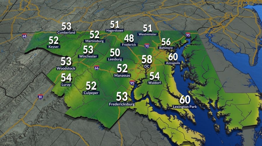
Residents across the Washington, D.C. metropolitan area awoke to an invigorating change of atmosphere on Tuesday, as a cool and crisp air mass swept into the region to deliver the first true preview of the upcoming autumn season. The early morning hours provided a noticeable reprieve from the lingering heat of late summer, offering an energizing start for students, commuters, and early risers stepping out the door.
Morning temperatures across the District and surrounding communities plunged into the 50s, generating a distinctly refreshing sensation that had been absent for months. The sharp dip in the thermometer established a cool baseline for the day, catching many who had grown accustomed to muggy mornings by surprise as they began their Tuesday routines.
For local meteorologists and weather watchers, the sudden temperature drop marks a noteworthy milestone in the seasonal transition. Prior to Tuesday morning, Washington had not recorded low temperatures falling into the 50s since June 3, ending an extended summer stretch that spanned well over three months of consistently warmer overnight readings.
Because of the sharp initial chill in the air, residents heading out for their Tuesday morning commute found that they needed a light jacket or extra layer before embarking on their travels. The crisp conditions made outer layers an essential accessory for the first time in many weeks across the greater capital area.
Despite the chilly beginning, the regional weather pattern is scheduled to deliver a comfortable and steady rebound as the day progresses. Temperatures are projected to climb efficiently throughout the late morning and early afternoon, ultimately settling into a very comfortable range between the upper 70s and lower 80s across the area.
Enhancing Tuesday’s mild afternoon is a generous supply of bright sunshine paired with exceptionally low humidity levels. These dry and pleasant conditions will create an ideal atmosphere for outdoor dining, recreational activities, and afternoon errands across the entire regional footprint.
Looking ahead to midweek, the pleasant meteorological pattern is expected to linger into Wednesday morning. The start of the day will once again feel crisp and refreshing, though thermometers will not drop quite as low as the readings observed during Tuesday’s initial cool snap.
By Wednesday afternoon, temperatures will begin a slight upward trajectory compared to previous days. Under predominantly sunny skies, maximum afternoon temperatures are forecast to climb into the lower to mid-80s, maintaining a mostly comfortable feel while hinting at a gradual return of late-summer warmth.
Forecasters strongly encourage local residents to take full advantage of both Tuesday and Wednesday. The rare combination of mild daytime warmth, bright skies, and comfortable dew points provides what may be the week's best window of outdoor weather before a muggier regime takes hold.
A distinct shift in the atmosphere is slated to begin on Thursday as humidity levels steadily rebuild across the region. Along with the creeping moisture, partly sunny skies will prevail as afternoon high temperatures push back up toward the upper 80s, reintroducing a noticeable summer-like stickiness to the air.
The unsettled nature of the late-week weather pattern becomes much more pronounced by Friday due to the arrival of a cold front approaching from the northwest. This incoming frontal boundary will interact with the warm, moisture-rich air sitting over the Mid-Atlantic corridor to destabilize the atmosphere.
Consequently, Friday will feature elevated humidity alongside high temperatures that peak in the upper 80s once again. As atmospheric instability builds throughout the daytime heating cycle, isolated showers and thunderstorms are expected to develop during the afternoon and persist into the evening hours.
Behind the initial frontal boundary, conditions will moderate slightly for the weekend, with high temperatures expected to level off in the mid-80s for both Saturday and Sunday. The slightly cooler daytime highs will offer some relief from the late-week peaks, though unsettled conditions may still impact outdoor plans.
Between the two weekend days, Sunday currently carries the higher probability of rain, with forecasters anticipating a better chance for scattered showers and thunderstorms to materialize over the metropolitan area during the latter half of the weekend.
As the region transitions into the subsequent work week, the forecast points toward a cooling trend under mainly cloudy skies. Monday's high temperatures are expected to hover right around the 80-degree mark, keeping conditions temperate as widespread cloud cover keeps direct sunshine at bay.
This evolving weather pattern smoothly bridges the gap toward the formal change of seasons on the calendar. Following months of summer heat and brief glimpses of crisp conditions, astronomical autumn is scheduled to officially arrive next Tuesday, ushering in the next seasonal chapter for the capital region.






(0)